A dataset to support wildland fire and fuel management in Greece created with stochastic wildfire simulations
Abstract
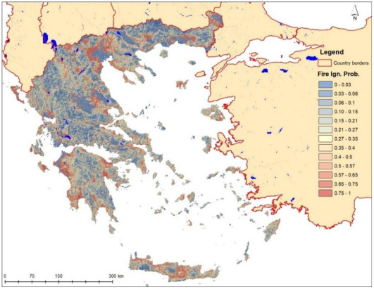
The potential spread and intensity of wildfires can be estimated with fire modelling simulators that produce valuable datasets which can be used during the prevention and suppression stages by fire management agencies. In the absence of observational data for all potential ignition sources, since a fire has not yet occurred or has burned many decades ago, fire behavior algorithms such as the Minimum Travel Time incorporated in the FSim simulator can be used to reveal these hidden fire patterns and trajectories. FSim is widely used in the USA for that purpose and its outputs, i.e., fire perimeters, ignition locations, fire intensity and burn probability are used in numerous assessments and applications, from fireshed delineation and community protection planning to exposure calculations of wildfire risk by the reinsurance industry. However, no country-scale application exists for Europe, due to the previous lack of essential model input data at an adequate spatial resolution (∼100 m), specifically fuel models, canopy base height and canopy bulk density. The EU H2020 funded project “FIRE-RES” filled that gap and produced the necessary input dataset at a pan-European level, enabling the first large scale nationwide stochastic fire behavior modelling application for Greece. The methods can be replicated and the datasets produced and presented in this work can be produced for every continental EU country. After retrieving the necessary spatial datasets from on-line open access repositories, we assembled them to create a landscape file. Greece was divided into 23 Pyromes that are regions with similar vegetation, climate and fire behavior. Then, weather patterns were summarized in a format compatible with FSim using hourly data of air temperature, dewpoint temperature, incident solar radiation, precipitation, and northward and eastward wind components for the years 2000-2021 from the state-of-the-art global reanalysis dataset ERA5-Land. Ignition locations were distributed across each Pyrome using an ignition probability grid, ensuring that we simulated enough fires so that each burnable pixel of the landscape experiences at least one event. Simulations were validated by comparing the historic fire size distribution of each Pyrome with the simulated one. The dataset includes the burn probability and conditional flame length rasters at 100 m spatial resolution, and the 3.65 million fire perimeters and ignition locations in vector format. In addition, we provide those input datasets that are not available in other repositories, specifically the modified fuel models and the ignition probability rasters. The data provided in this article offers a valuable resource for fire management and civil protection agencies, enabling them to understand the fire size potential of each area and the expected burning intensity. In addition, metanalyses of fire perimeters intersecting them with settlement boundary polygons can provide their exposure profiles to inform fuel treatment and community protection plans. Risk profiles may also be produced by linking exposure with expected fire intensity, even at building level, providing useful datasets for insurance purposes and spatial planning.