The relationship between fire severity and burning efficiency for estimating wildfire emissions in Mediterranean forests
Abstract
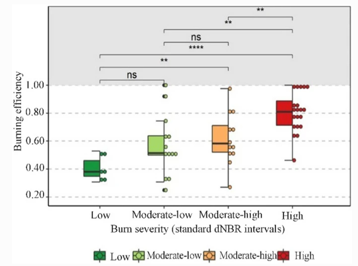
Forests are exposed to changing climatic conditions reflected by increasing drought and heat waves that increase the risk of wildfire ignition and spread. Climatic variables such as rain and wind as well as vegetation structure, land configuration and forest management practices are all factors that determine the burning potential of wildfires. The assessment of emissions released by vegetation combustion is essential for determining greenhouse gases and air pollutants. The estimation of wildfire-related emissions depends on factors such as the type and fraction of fuel (i.e., live biomass, ground litter, dead wood) consumed by the fire in a given area, termed the burning efficiency. Most approaches estimate live burning efficiency from optical remote sensing data. This study used a data-driven method to estimate live burning efficiency in a Mediterranean area. Burning severity estimations from Landsat imagery (dNBR), which relate to fuel consumption, and quantitative field data from three national forest inventory data were combined to establish the relationship between burning severity and live burning efficiency. Several proxies explored these relationships based on dNBR interval classes, as well as regression models. The correlation results between live burning efficiency and dNBR for conifers (R = 0.63) and broad-leaved vegetation (R = 0.95) indicated ways for improving emissions estimations. Median estimations by severity class (low, moderate-low, moderate-high, and high) are provided for conifers (0 .44 − 0.81) and broad-leaves (0.64 − 0.86), and regression models for the live fraction of the tree canopy susceptible to burning (< 2 cm, 2 − 7 cm, > 7 branches, and leaves). The live burning efficiency values by severity class were higher than previous studies.